The geologist is interested in collating and understanding all data which originates from a borehole. The data may be in the following forms:
Geological samples
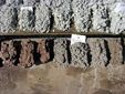
- Cylindrical core samples from an interval of the borehole or the whole borehole.
- Chip samples from the borehole.

Geophysical samples
- Geophysical borehole logs (remotely collected data from probes in the borehole.)
Other samples
- Physical sample of fluids and/or gas.
Correlating geophysics to geology is a key requirement. Commonly this is straight forward but an understanding of the sampling process for both datasets will aid the correlation and answer questions such as:
– Why do my data sets seem to have a depth mismatch?
– Why do my resource grades differ between geological samples and geophysical logs?
Drilling Depth Mismatches
- Incorrect count of drill rods, misnaming of sample bags or a short starter drill rod.
- Crude sampling – openhole sampling during drilling is commonly through a drilling offsider using a sieve and the driller marking off a metre on the drill rod. This generates a pile of sample for that 1 metre. A crude but generally effective method.
- Sample lag – The greater the depth of the borehole the more likely a depth lag will occur between the depth of the drill bit and the time the sample is received at the surface. Oil & gas drilling have a service sector to monitor drilling fluids, pump rates and sample returns at the surface. This type of monitoring is very rare in mineral exploration.
Logging Depth Mismatches
- A poorly calibrated depth on the logging unit, incorrect assignments of probe/stack lengths by the logger, incorrect assignment of ground level or “upstick”.
- Mud on the depth measuring wheel.
- High speed on the downhole trip in and/or slack wireline due to a blocked borehole.
- A high logging speed uphole – leading to smearing of peak responses.
Difference in sample grades and log grades
It is not uncommon for drilling samples and hence laboratory sampling to be based on a minimum of 1m (commonly 2m or more). This will be the limit of the vertical resolution for the geological data. Geophysical logs are typically sampled every 10cm or 5cm or 1cm. This gives much greater vertical resolution for geophysical logs.
Additionally, the volume of investigation for the different methods needs to be considered:
- The volume of investigation for the geological data is the drilled diameter.
- The volume of investigation for geophysical logging is generally greater or much greater than the drilled diameter. For example a simple gamma log can have a sphere of investigation some 20cm in diameter.

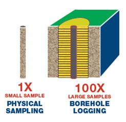
The type of rock intersected by the borehole can influence the geophysical probes volume of investigation. For example a density probe’s volume of investigation is less in higher density rock compared to lower density rock.
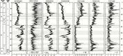
The example below compares laboratory measured grades for Uranium and a calibrated gamma log for equivalent uranium. Whilst a quick look shows good correlation between the geophysical log data and the laboratory grades taken from drill chip samples. Look closer and you’ll see examples where the mineralisation is in thinner horizons than the sample rate of the drill samples (here every 2m). What is quite common is to see higher grade in the log data averaged over several metres in the drill chips.
